
Topographical Surveys
Topographic Survey
South West Surveys are based in Bristol and travel throughout the UK offering highly detailed and precise surveys to every sector at affordable prices.
Our surveys will record every detail of the site, whether it be natural or manmade features.
Our surveys are delivered in PDF & DWG files and can be produced in 2D or 3D.
Topographical Surveying Services:
- Precise monitoring
- Setting out
- Area & volume calculations
- As built survey (sect 38,104 +278)
- Site section
- Utility tracing (PAS128)
- Boundary surveys
- Determined boundary plans
- Land Registry Plans
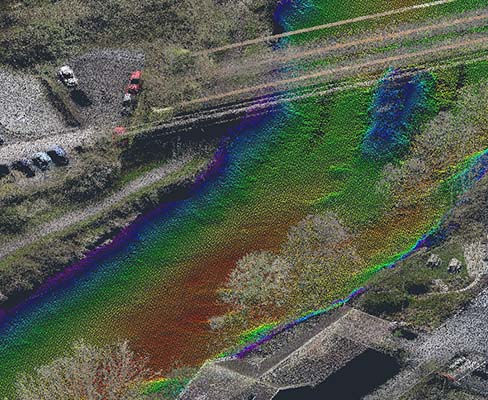
- Inshore & Bathymetric surveys
- Motorway surveys
- Railway surveys
What are Topographical Surveys?
A Topographical or ‘topo’ survey, also known as a land survey, provides an accurate representation of natural and manmade features within a specified area.
They are usually completed by using a range of specialist surveying equipment that can be used to measure and identify angles and distances effectively.
To obtain precise measurements, we use GPS survey equipment in order to locate fixed points of an area of land.
These points are used as reference markers, and they are used to demonstrate the height and base of the specified area.
With these markers you can produce a CAD (computer-aided-design) drawing, which illustrates a highly detailed and accurate topographical map of your land.
Why You May Need a Topographical Survey
Topographical surveys are typically developed for architects, contractors, engineers and designers.
However, they can be useful for anybody with a project.
They are most useful when working on land progress projects, and they can help to avoid any complications in the process of development.
When working on a design, a land survey can provide you with exact and precise plans and coordinates to help you get creative in the planning and layout process.
The Benefits of a Topographical Survey
Topographical building surveys serve many purposes such as:
- Identifying existing conditions and issues with a site.
- Illustrating how building features can be constructed electronically, by using CAD.
- Demonstrating any obstacles that may cause problems with the site’s development.
- Providing information that can aid designers in creating suitable designs for the specified site.
How We Conduct Topographical Surveys
The type of equipment for a topographic survey varies depending on the land and preferences of the surveyor.
Environmental conditions will be considered when selecting the appropriate tools in order to attain ultimate accuracy.
In wider and more open spaces, the assessor will utilise a GPS signal as it is less likely that large obstacles will interfere with the survey.
In industrial areas, a GPS system is not suitable. Therefore, a robotic total station instrument will be used instead, which is used to measure horizontal and vertical angles as well as sloping distances.
However, if an area is inaccessible or too dangerous to collect data, we use reflector-less technology.
We can carry out basic surveys, picking up only key features if required, but surveys usually include all detail including trees, shrubs, roads, paths, inspection chambers, drainage covers and invert levels etc.
Once the data has been collected, it will be stored electronically. The data is then processed on a computer to produce the final drawings on CAD.
The Types of Sites We Survey
We are equally adept at producing surveys for green sites and urban sites.
Sites benefitting from a topographic survey may vary from private residential alterations to large scale developments, roads, railways, farmland, civil engineering projects etc.
Clients include private property & land owners, architects, engineers, utility companies and developers.
Whether you are looking to develop a small plot of land for a new home or undertaking a major infrastructure project that spans hundreds of acres, our surveyors can create the plans you need to move your project forward.
Topographical survey drawings are provided in CAD 2D and/or 3D as required and in PDF format. Paper and film copies can be supplied if requested.
Getting a Topographical Survey
Our team of land surveyors work on projects throughout the whole of the UK, but our close proximity to the South West means we’re perfectly positioned to carry out topographic surveys in and around Bristol, Bath, Cheltenham and Gloucester.
If you are interested in our services please do not hesitate to call us, or if you have any enquires, our team would be more than happy to help!
Services We Offer
Precise Monitoring
Setting Out
Area & Volume Calculations
As Built Survey (sect 38,104+278)
Site Section
Utility Tracing (PAS128)
Boundary Surveys
Determined boundary plans
Land Registration Plans
Inshore & Bathymetric Surveys
Motorway Surveys
Railway Surveys




Contact Us Today
Use our form to estimate the initial cost of renovation or installation.